 By John Booth © - 2 December 2013
Everyone has something to add. In conversations around the state of the waters of the Bay of Islands, it’s not long before the seagrass (= eelgrass) beds—or the spoiling of them—crops up. Whereas in previous times mangroves were often seen as the great ecological refuge, seagrass meadows have largely taken on that mantle—much to the relief of many who thought mangroves sucked anyway.
And it does seem to be that healthy seagrass goes hand in hand with flourishing marine ecosystems: clear waters, low rates of silting, and little fertiliser or other muck running off the land. Seagrass are as productive as the best of paddocks, and they are also important nurseries for many fishes—especially snapper, trevally, parore, spotties and piper. And in turn seagrasses are food cupboards—small crustaceans, worms, shellfish and so on—for all manner of creatures, fish to fowl, to pick over.
There’s just the one seagrass in New Zealand: Zostera muelleri (to Maori, rimurehia—although rimurimu in the eastern Bay of Islands), for one Baron Sir Ferdinand Jakob Heinrich von Mueller, Government Botanist for Victoria—immediately indicating that this species is also found in eastern Australia. The only true flowering plants to grow in the sea (although not true grasses, being more closely related to lilies and gingers), seagrasses must have sufficient light in order to photosynthesise. The leaves trap fine sediments by slowing water movement and encouraging particles to settle to the seafloor, greatly improving water clarity. The clearer the water, the better the seagrass thrives; and more seagrass means clearer waters.
So, where can we still find seagrass beds in the Bay of Islands, and how much have their extent and distribution changed over time? Are they likely to persist—or is that it for them?
Motuarohia (if you must, ‘Roberton Island’) was where James Cook first set forth in the Bay of Islands, to meet close-up—real close up—the locals. His engagement there, one Wednesday late in November 1769, was so tense that only a line in the sand backed up by musket fire and reports from the ship’s guns gave him confidence and prevented his demise. A bronze plaque celebrating the moment is banished to a reef at the western end of the bay, seldom if ever read. It so happens that this island is also, it seems, the first with an aerial image useful for seagrass, taken by Leo White, of Whites Aviation fame in the 1930s. Photographs like this are of more than just passing nostalgic interest; they are key to the past with respect to many things on both the land and in the sea. Earlier—still, reliable—records of seagrass distribution will lie within the memories of older peoples, but these emissaries have been dropping like flies ever since the first canoes arrived.
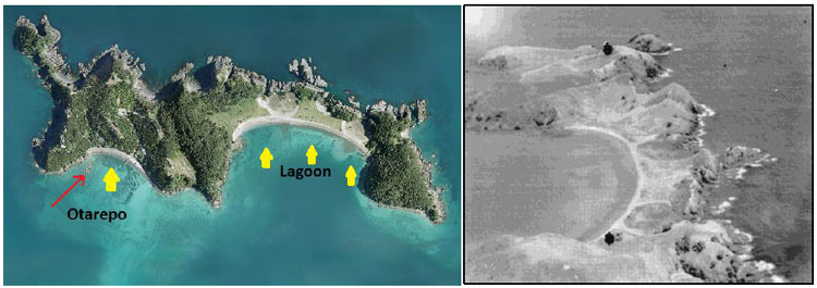
Seagrass was clearly visible (yellow arrows) at Motuarohia Island this bright spring day in 2009 (left, the red arrow indicating the reef bearing the plaque to celebrate James’ setting forth on Otarepo Bay in 1769). In the 1930s, the island was largely free of vegetation (right)—and of seagrass too, in my opinion. The shadow at the top of Lagoon Bay is seaweed growing on a reef. (Sources: Ocean Survey 20/20; Alexander Turnbull Library 1367622)
Leo’s shot of Motuarohia shows a remarkably naked landscape, dominated by a land-yoke of lagoons which from time to time would be momentarily breached to make the island more than one. Lagoon Bay (the original name for which continues to elude) provided me no evidence of seagrass. The lip-stick smudge along its length—in places linked with shadows in deeper waters—is not dark enough to be seagrass. I’d be more confident that the dark shadows at Otarepo Bay (Cook’s Cove) included seagrass.
We were at the height of the war when the next aerial photograph that I have for Motuarohia was taken. Zooming into this high-resolution image, which holds far more detail than is apparent at the scale reproduced here, I convinced myself there was a small amount of seagrass in Otarepo, and more in Lagoon Bay.
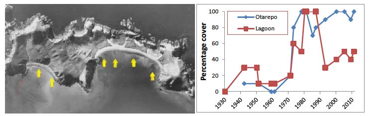
Motuarohia Island on 3 June 1942 (left), the yellow arrows indicating likely seagrass. (Note how dark the reefs at the western end of both bays appear compared with in 2009: the kelp that flourished on these and other reefs had disappeared by the 1980s, almost certainly under the grazing pressure of the Aristotle lanterns of kina, to become the kina barrens you find there today.) The fortunes of the seagrass beds of Motuarohia Island are expressed as percentage cover relative to that on the date with the greatest extent of seagrass (right). (Photo source: Department of Conservation)
The Bay of Islands aerial photos of Whites Aviation (reveal on the National Library of New Zealand website using the search words aerial bay of islands) typically bring dramatic perspective and may convey us back to rapidly fading memories of childhood. Despite flying machines having been more or less regularly in the skies over at least parts of this country since the 1930s, it seems to be more than a decade on that images combining sufficient height with better-than-Box-Brownie lenses became more or less routine. Leo and co.’s focus seems to have been the eastern islands—and particularly Urupukapuka with its world-famous Otehei Bay deep-sea angling base. There’s every chance Leo seized any opportunity to tiki-tour on a pretty summer’s day, perhaps with a fare-paying fan or family of the famous Zane Grey aboard. But these were more than happy-snappy shots—they are high resolution photographs into which one can drill down with a great deal of satisfaction, to reveal items as small as 2 metres across.
Somewhat lacking in character, but ultimately more useful because they look down vertically on the surface of Earth in a synoptic manner to take in the entire landscape, are the series of high-definition aerial photographs bearing Crown Copyright but attributed to New Zealand Aerial Mapping. The earliest ones I could find useful for the Bay of Islands were from the early 1950s. Parallel lines were flown with a small amount of overlap allowing adjacent pairs of photographs to be spun up to 3D, bringing to mind Victorian parties of elegant, gloved individuals, entranced by cards viewed through one of those stereoscopic thingamajigs. You are presented with a mosaic of light and dark forms, hints of roads and rail lines, and even individual houses. And that’s before you start to zoom in. The images really help with estimating seagrass distribution—at least the subtidal beds which, because of the way light penetrates water and is absorbed, appear as discrete shadows on the seafloor.
I went through these and other images for each bay and identified the one that showed the most extensive seagrass—and this was allocated a coverage of 100%; the extent of the seabeds in all other images were rated, by eye, relative to that winner. Fortunately, most of the photographs were from spring and summer, when the seagrass is at its best. And for Motuarohia there appears to have been a distinct pattern over time: in both Otarepo and Lagoon bays, the seagrass beds were least extensive in the early period; at their bumper-best in the mid-1970s to mid-1980s; and from then on Otarepo Bay continued to perform well, whereas Lagoon Bay was pretty ho-ha.
Moturua Island also holds heaps of history—and has certainly had its share of seagrass. Marion du Fresne’s crews made love and war here, their weapons including varieties of the pox, and powder. Waipao, where the sick sailors were holed up under canvas and where the routed French had re-trenched before their awful slaughter of Paeroa Pa (immediately to the right of the uppermost yellow arrow in the aerial photograph below) in the winter of 1772, has held the best of the seagrass.
Again there is consistency in the seagrass between bays. There was little at all to crow about in the early 1950s. And then, like at Motuarohia, everything was pretty-much hunky dory during the mid-1970s and 1980s—until a crash, which coincided uncannily with that of the world’s stock markets. Ngati Kuta Kaumatua Matu Clendon, who spent a good portion of his boyhood at Otupoho, can’t help but remember the seagrass there: that’s where he netted piper, the main bait for the commercial fishing that supported the family. All gone. Hahangarua and Opunga seagrass took a dive too, but at least licks survived near the beach edge. Only Waipao seagrass flourished, where to this day it appears more a meadow than just a spotty bed.
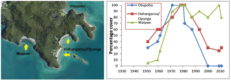
Moturua Island was once home to the French—and, in 2009, to seagrass in Otupoho, Opunga, Hahangarua and Waipao bays (left). Only Waipao Bay has continued to perform really well (right). (Photo source: Ocean Survey 20/20)
There have been—and still are—small patches of seagrass around Waewaetorea Island, but not sufficient, really, to call beds, and certainly not meadows. Urupukapuka Island has five separate beds, with a variety of fortunes. Otiao (Entico) is special to local Maori in respect of their great chief, Te Kemara, a notable presence in February 1840; and for its seagrass. Urupukapuka Bay, first occupied in the 1500s according to recent archaeological excavations, is also a star. There was similarity in pattern over the years between these two bays, even though they are on different sides of the island: not much going on in the early 1950s and early 1980s, but generally good performance between times and recently. In contrast, seagrass in the more-or-less adjacent Otehei and Kapurarahurahu (Cable) bays was best in the 1970s to mid-1980s, while Oneura (Paradise) was all over the shop.
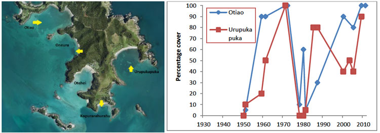
In November 2009, there was no evidence of seagrass in Otehei Bay, but Otiao and Urupukapuka bays were magic. (Photo source: Ocean Survey 20/20)
The mainland adjacent to these islands has also harboured significant seagrass beds. Interviews of Ngati Kuta’s old people by Helen Harte suggested there used to be seagrass in Maunganui Bay; Anya Hook and Helen told me that it was once at the south end of Oke Bay; and in the aerial photos I saw it from time to time in bays such as Omakiwi. But the real performers are clustered near Te Rawhiti itself, these beds being particularly significant because they are among the few subtidal ones anywhere in the North Island associated with the mainland, rather than with islands. Here—where, in great battles in the early 1800s, Nga Puhi vanquished Ngare Raumati—we see the fortunes of the beds changing so much that the graphs are as sharp as saw teeth. And I’m blowed if I can discern any pattern to the denticulation. Perhaps what is reassuring is that in the face of what appears utter extirpation, the seagrass has been able to bounce back pronto—as if the mauri hid within the sediment, waiting for the right moment to once again express itself for all to take notice of.
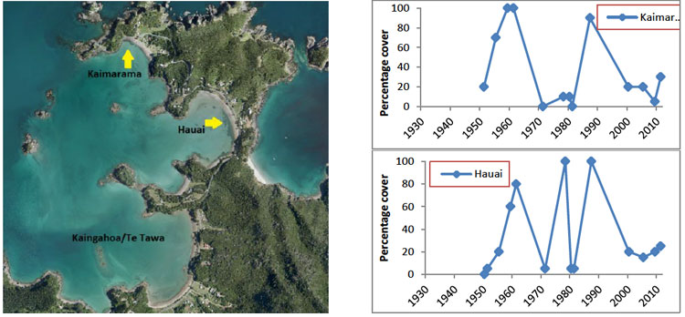
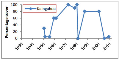 In November 2009, Kaimarama and Hauai had small beds of seagrass, but Kaingahoa appeared bereft. The good news: there are now, four years on, extensive beds in Kaingahoa, attesting to a remarkable ability of seagrass to bounce back. (Photo source: Ocean Survey 20/20)
But my canvas was broader than just the eastern Bay of Islands. I examined dozens of aerial images taking in the entire Bay for evidence of seagrass, most from the 1950s on. I could find no evidence of seagrass in the Waikare or Waikino Inlets; Myra Larcombe, who grew up on the banks of the Waikare in the 1940s to 1950s, told me that she never came across significant seagrass in either inlet. But there were strong spots evident in the Ti Mangonui Inlet, and particularly Hauparua Inlet near the southern entrance to the Kerikeri Inlet in the very early images. These tied in nicely with the memories of kaitiaki and long-time fisherman of the northern Bay of Islands, Richard Civil of Rangitane, who showed me on Pickmere’s atlas where patches used to exist.
So far the conversation has been entirely around seagrass that is constantly submerged. But in fact seagrass in New Zealand today is predominantly intertidal, forming extensive beds or mosaics of discrete patches surrounded by otherwise naked sediments, particularly on estuarine sand-flats. In just a few places the beds magically extend, as if an altogether separate being, as subtidal fringes into sheltered-water shallows, to depths of 6 metres or so. Submerged seagrass probably hasn’t always been quite so unusual or so patchy, its absence in most New Zealand harbours these days attributed primarily to the water being just too foul to allow sufficient light to reach the seafloor. Accordingly, subtidal seagrass meadows are of great interest to marine ecologists, and should marine reserves ever be established in the Bay of Islands they must include at least one.
Being so in-your-face, intertidal seagrass beds—in contrast to those constantly submerged—should be easier to nail down, yet for the Bay of Islands they have proved elusive. There has been no flood of reports or memories of greenery between the tides. And the aerial photographs haven’t been very helpful: they seem to be most useful when the grass is submerged, and especially where there is a light-coloured sand background to provide contrast. To reinforce the point, they failed to reveal intertidal seagrass meadows in Parekura Bay that in 1987 covered 14.7 hectares (although, admittedly, there wasn’t a photograph for that year). Revealed in a Department of Conservation survey, this was the most significant seagrass bed—and, with the patch opposite, the only intertidal seagrass of more than a few square-metres—in the entire Bay of Islands. Today you’d be lucky to find a tuft there.
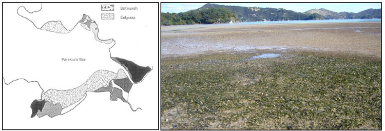
This 1987 intertidal bed in Parekura Bay (left) was the largest seagrass meadow in the Bay of Islands in the mid-1980s (labelled eelgrass and previously larger; shading also shows saltmarsh and mangroves). Seagrass is now establishing good-o in Whiorau Bay (above). (Sources: Department of Conservation, John Booth)
That’s been seagrass in the Bay of Islands over the past 60-odd years, but there’s no reason to think it’s always been so restricted. I imagine that in a pristine setting, before deforestation by fire and silt-generating logging muddied the waters, seagrass meadows would have covered much of the shallow mud/sand shores of the Bay of Islands.
Seagrass beds in New Zealand—both intertidal and subtidal—have vanished all over the place, with only about 4400 hectares left; on a good day, up to about 10% of these are in the Bay of Islands. We can thank our lucky stars that in the late 19th century, when prolific meadows in certain parts of the country led to proposals to harvest and export the seagrass for mattress and furniture stuffing (samples having fetched 10 pounds a ton in the Old Country), sense prevailed. In fact, it seems that the greatest losses have been since the 1920s and 1930s—probably largely through there being too much silt in the water. Other factors to seriously impact on seagrass distribution and survival include disease and too much nutrient in the water.
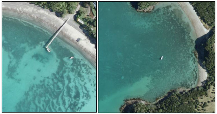
Serendipity? The area clear of seagrass appears to be at the point of prop wash for this wharf in the eastern Bay of Islands (left); and there appear to be anchor drag-lines through the seagrass in this popular overnight anchorage (right). (Source: Ocean Survey 20/20)
To sum up, the recent fortunes of seagrass in the Bay of Islands present a mosaic of understanding as patchy as the seagrass itself. There were consistencies in the patterns between bays, but gross outliers too. If there is anything to conclude, it is that the seagrass thrived least well overall in the early period (mainly 1950s), were at their best in the 1970s and 1980s, and have been variable since. I can’t pin that pattern on anything particular, such as changes in El Nino-Southern Oscillation which have had a lot to say in the fortunes of other marine species. Also, had there been data for each and every year, the pattern may have looked very different, for we have seen how the surface manifestation of seagrass beds can plunge—yet bounce back—in short order.
My take on things is that the remaining seagrass beds in the Bay of Islands—all out east—are safe for the time being, providing silting, in particular, is modest. We all desperately seek clarity if our seagrass is to thrive! Major sources of silt include roads, property development, and deforestation. While small-scale disturbances caused by anchors and propellers can recover their surface imprint within a year or so, more severe damage takes much, much longer: disturbance of an area of seagrass bed in Tauranga Harbour, during the laying of a pipeline, was still evident 20 years on.
In the meantime, there’s good news: intertidal shores for decades subject to silt flowing from an unsealed road with its associated drains, banks and dust-covered foliage, are now showing patches of luscious green. Is it just coincidence that the road was sealed a couple of years ago? Possibly—but take a deco high up on the shore the next time you’re out there collecting cockles in Whiorau Bay, and see what you think.