By John Booth 3 February 2015
Download this article as a pdf
Sea urchins (kina) have eaten out much of the shallow-water kelp of the Bay of Islands, defiling the Bay's essential life force. There appears no other credible explanation for the kelp loss. Similar destruction has taken place in many other parts of New Zealand, as well as overseas. The experience is that sea urchins increase in abundance as their key predators become overfished; the sea urchins consume or destroy the kelp over the band of the urchins' depth distribution; and this leads to the collapse of natural functioning of shallow-water reef ecosystems.
Marine reserves in New Zealand and elsewhere show that when fishing pressure on the predators of sea urchins is removed, the full canopy of kelp returns. No-take reserves lead to fully functioning kelp ecosystems—their dependent life forms and ecological processes re-established. The imposition has been so great it will take decades to repair. But the sea's mauri can be restored.
~~~~~~~~~~~~~~~~~~~~~~~~~~~~~~~
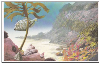
The number of living creatures of all Orders, whose existence intimately depends on the kelp, is wonderful. A great volume might be written, describing the inhabitants of one of these beds of seaweed.... I can only compare these great aquatic forests of the southern hemisphere with the terrestrial ones in the intertropical regions. Yet if in any country a forest was destroyed, I do not believe nearly so many species of animals would perish as would here, from the destruction of the kelp.
Charles Darwin had recognised the great variety of invertebrates, fish and other seaweeds that make up the community of the giant kelp forests of Chile during his visit there in 1834. Ironically, what unfolded decades later among many of the world's giant kelp forests was their almost total annihilation by sea urchins. This was made possible because kelp forests are among the very few of the world's large-plant communities where essentially all individual plants can be grazed by a single herbivore.
~~~~~~~~~~~~~~~~~~~~~~~~~~~~~~~
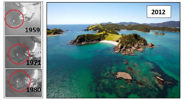
As James Cook was being rowed towards Otarepo Bay on Motuarohia Island for his first foray ashore in the Bay of Islands, late in 1769, his bowman would have been on sharp lookout for submerged reefs, anxious to avoid the ignominy of striking bottom—even upsetting the craft—in front of the threatening crowd gathering on the beach ahead. The sailor could see the large reef on his port quarter, its presence unmistakeable through the dark mass of kelp attached.
Today, the bowman might be forgiven for their bumping the reef, for no longer is its presence given away by a dark mantle of seaweed—hasn't been for decades. Instead the reef appears ghoulish grey and lifeless, virtually naked of large kelp.
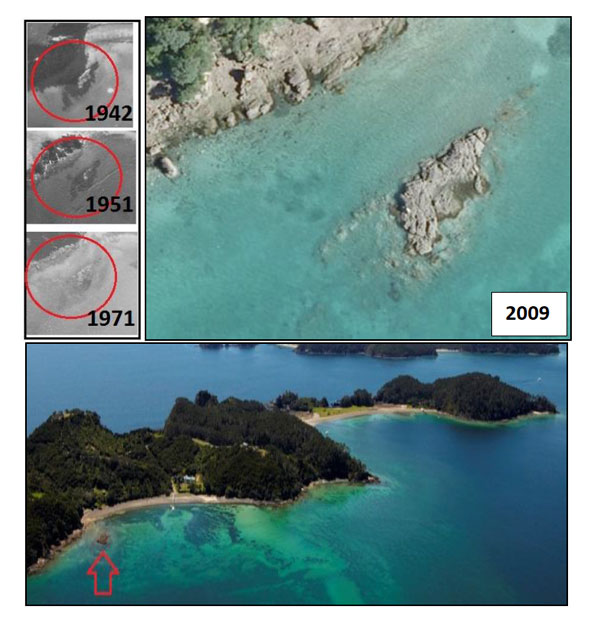
The reef, 10 metres across, at the western end of Otarepo on Motuarohia Island was once festooned with kelp. The sequence of aerial photographs shows it had become essentially bereft of cover by 1971. (Photos: NZ Aerial Mapping; Oceans 20/201, Salt Air)
Samuel Marsden would have untold times unconsciously registered the dense, flourishing seaweed on the boulders and reefs at each end of his little beach of Hohi during his visits to the Oihi Mission in the northeast of the Bay of Islands. Extending from near low tide level down as far into the water column as he could make out, every rock would have appeared to Marsden as a swirl of brown on even the stillest of days when, as if by magic, Tangaroa sought to once again rearrange things beneath the surface.
Yet today, should Marsden return, he would find largely bare rock, with just a lick of seaweed—like eyebrows—at low tide level. After having been rendered essentially invisible from above for millennia by their crop of leafy brown, the rocks now reveal something of their own colour interpreted for our eyes through the general whiteness of the low-profile encrusting organisms hugging their surfaces.
Gone too, of course, are the multitudes of animals and other algae that once made use of that complex luxuriance of kelp. The reefs at the eastern end of Hohi appear today as a lunar landscape.
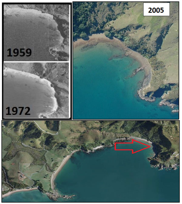
Virtually no kelp cover remains on the reef phalanges and faces that reach out from the beach at Hohi, at the eastern end of Rangihoua Bay (Marsden Cross); it had largely disappeared by 1972. (The reefs near the base of the arrow appear dark mainly because of the rock type—not through kelp cover.) (Photos: NZ Aerial Mapping; Vince Kerr; Ocean Survey 20/201)
The kelp community of the string of idyllic islets which marks the outer edge of the archipelago of Ipipiri, and for which the Bay of Islands is so well known, has been similarly attacked—at least on the more sheltered margins. Take Te Akeake Point, on Urupukapuka Island, where the kelp has simply been devastated by voracious Aristotle's lanterns. The destruction has taken place over the main depth range of kina: from a little below low-tide level to about 8 metres.
Today, the reef off Te Akeake, the northwest extremity of Urupukapuka Island, displays a fringe of kelp at low tide level, and then again from about 8 metres depth. What you can't quite make out are the thousands of puny kina busy rasping their way across the intervening area. (Photos: NZ Aerial Mapping; Salt Air)
~~~~~~~~~~~~~~~~~~~~~~~~~~~~~~~
These examples of loss of kelp cover have been for small reef-systems, yet they represent a great proportion of the rocky shores that fringe the main basin of the Bay of Islands.
 In the 1970s, scientists working on the northeast coast of New Zealand began to wonder if the kelp-free zone just below low-tide level to about 8 metres depth—appearing a bit like a tanned bather caught with their pants down—and home to dozens of grazing sea urchins was natural. It wasn't, the condition strikingly captured by Ronald Cometti.2
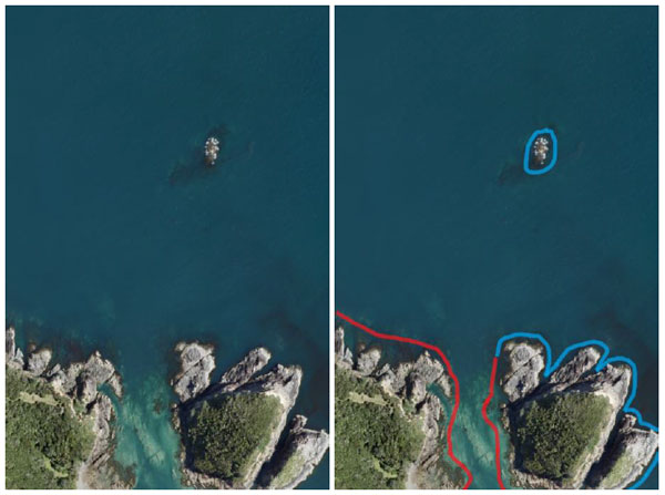
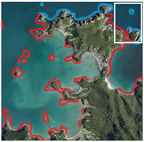
High-definition aerial photographs taken of the Bay of Islands at low tide one day in spring 2009 provide a keen sense of the modern extent of the kina barrens. The dozens of individual Ocean Survey 20/20 aerial images1 were marked up (green where the kelp on the reef appeared to be largely intact, thriving at and below low-tide level; blue where the photographs weren't useful or else kelp-covered rock couldn't be distinguished from dark-coloured rock devoid of kelp; and red where the kelp was largely confined to a narrow low-tide fringe and/or to deep water) and then amalgamated and interpolated into four images for the entire Bay of Islands (see appendix).
As these images demonstrate, large areas of Bay of Islands' shallow reef are now devoid of kelp.
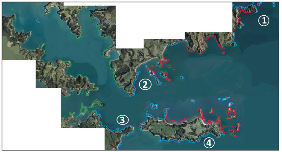
In the north of the Bay of Islands in November 2009, kelp appeared to be largely intact in the lower reaches of Te Puna and Kerikeri inlets (green), but heavily grazed along northern faces and along the north coast of Moturoa Island (red). At 1, the reef was too steep to assess, or was in shadow; at 2-4, the reef itself appeared dark, most probably for reasons other than kelp cover. (Based on Ocean Survey 20/20 aerial photographs.1)
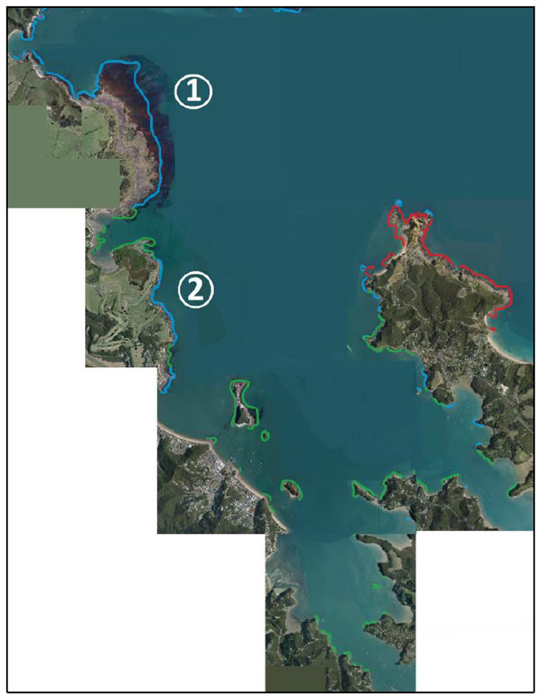
In the south of the Bay of Islands in November 2009, kelp appeared to be largely intact along the shores of Veronica Channel (green), but heavily grazed east of Tapeka Point (red). At 1 and 2, the reef itself appeared dark, but not necessarily because of kelp cover. (Based on Ocean Survey 20/20 aerial photographs.1)
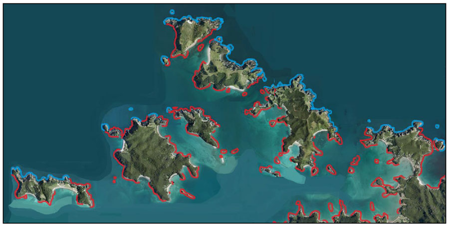
Kina barrens (red) were widespread in Ipipiri in November 2009; open shores were typically too steep to assess, or were in shadow (blue). (Based on Ocean Survey 20/20 aerial photographs.1)
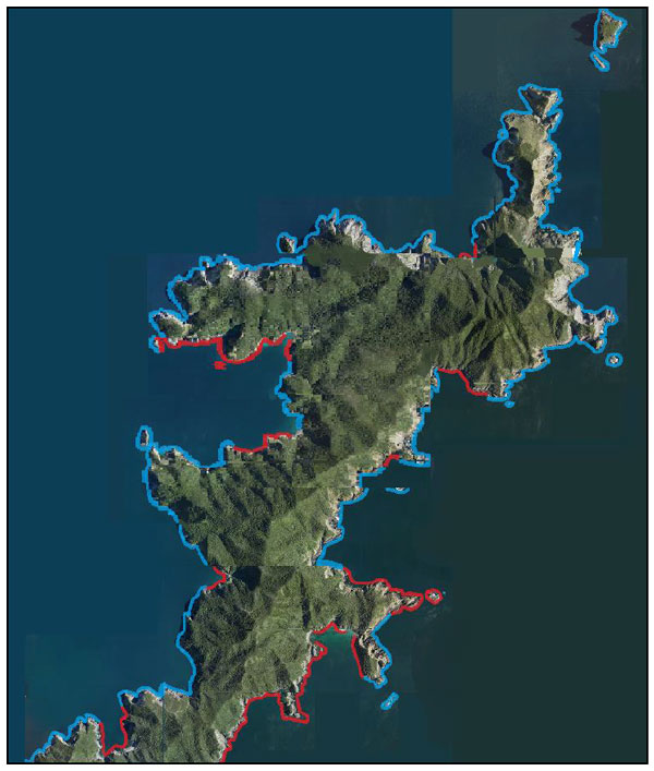
Much of the reef of Cape Brett Peninsula was too steep to allow evaluation of the state of the kelp forests, or was in shadow. Nevertheless, in November 2009 kina barrens were widespread on both sheltered and exposed shores. Ground truthing of several areas shown blue revealed extensive barrens interspersed with patches of healthy-looking kelp. (Based on Ocean Survey 20/20 aerial photographs.1)
~~~~~~~~~~~~~~~~~~~~~~~~~~~~~~~
But taihoa! Aren't patches of bare reef part and parcel of a perfectly natural state? Afterall, reef ecosystems change and evolve according to variable year-to-year success among species, disease outbreaks, storm events, ocean-climate effects, and so on.
But if any of these was the cause of kelp retrenchment on shallow reefs in the Bay of Islands, surely we would have found individual patches of kelp waxing and waning independently of each other over time, or extensive areas waxing and waning without obvious trend. Yet in the 29 pozzies in the Bay of Islands for which there was a series of aerial photographs, from the early 1960s or before through to the present, in which the extent of seaweed cover could be clearly discerned, assault on the kelp communities was all one way.
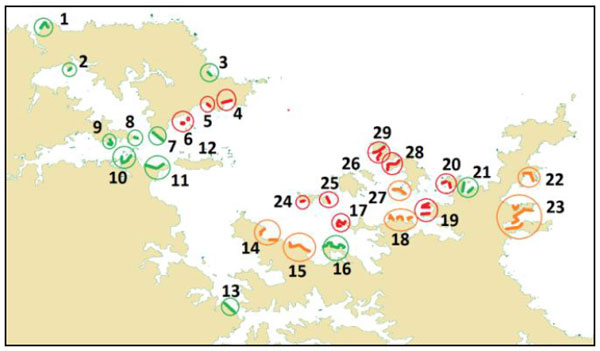
Changes in kelp cover between the 1950s/early 1960s and 2009. For each site there were at least four aerial photographs, each separated by at least a decade, and among which at least two of the early photographs showed extensive dark shadows associated with reef (usually kelp but possibly sometimes dark-coloured rock). The previously existing dark shadows had largely vanished by the 1970s (red), or certainly by the 2000s (orange); green indicates little apparent change in the intensity or extent of shadow (although thinning of kelp was sometimes obvious).
~~~~~~~~~~~~~~~~~~~~~~~~~~~~~~~
When all the 'i's are crossed and 't's dotted (as Mrs Malaprop might have put it), the results boil down to this. For most parts of the main basin of the Bay of Islands the change in kelp cover has been monumental. Decline was obvious by the 1970s, although some forests did stagger along until quite recently. Although the depth range of eaten-out kelp varies somewhat from place to place today, the take-home message is the same: widespread devastation.
Thankfully—and in contrast—there appears to have been little change at all to the kelp cover of inner areas, such as near the mouths of the inlets where waters are too fresh for kina to thrive.
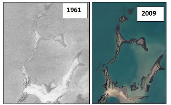
These islets of basalt at the mouth of the Kerikeri Inlet resemble the fossil remains of some elegant taniwha. The dark fringes are seawrack kelp, and the impression is that the seaweed is just as prolific now as it was in 1961. (Photos: NZ Aerial Mapping; Ocean Survey 20/201)
For the open shores of the Bay of Islands, it's a bit of a dog's breakfast. There certainly has been loss of kelp cover, in some cases quite recently; for other areas, the kelp still appears to be reasonably intact. Possibly this is because wave action on these shores is just too severe to allow kina populations to gain a foothold and explode. Also, the densities of key kina predators such as large snapper, blue cod, porae and rock lobster may be greater there than within the Bay itself, sufficient to keep the kina in check—for now.

Patches of healthy kelp can still be found off open shores of the Bay of Islands, but they're under pressure from sea urchins. From left to right: the brown kelp Lessonia; agar weed Pterocladia; and seawrack Carpophyllum; with the common kelp Ecklonia deeper down. (Photos: Roger Grace) In contrast, the only obvious life on a kina barren is the sea urchin Evechinus chloroticus. (Photo: Tim Booth)
~~~~~~~~~~~~~~~~~~~~~~~~~~~~~~~
The aerial photographs have shown how the change in kelp cover for the bulk of the Bay of Islands has been essentially one-way, most shallow reefs having become largely devoid of kelp by the 1970s or 1980s, with no evidence of recovery since. The only plausible reason so far proffered for Northland's long-term, widespread kelp loss within a narrow depth band, with no obvious healing, is removal of the main predators of kina.3 It's hard to see how the limited levels of ocean warming or ocean acidification evident so far could have brought about such widespread destruction of kelp within just the main depth zone of kina—and not elsewhere.
And Northland—or New Zealand for that matter—is not unique in its pronounced and widespread ecological change. 'The emergent and globally coherent pattern shows urchin grazing to cause a discontinuous 'catastrophic' regime shift....' is the very recent (2014) alarming conclusion of an international panel of scientists.4 They go on: 'Once shifted, strong feedback mechanisms provide resilience for each alternative state thus defining the catastrophic nature of this regime shift.' In other words, the kina-barren is alarmingly resistant to reversal.
Now here's the crunch: this catastrophic loss of kelp forests coincided with intensification of commercial fishing inside of, and out from, the Bay of Islands. (It's exactly the same in many other parts of the world.5) And in recent times, the pressure once exerted by the Bay's commercial fishers has been more than matched by incredibly heavy recreational fishing.6
For snapper, overfishing meant that abundance declined dramatically throughout New Zealand during the 1970s and 1980s.7 Bay of Islands is in the East Northland substock of the SNA 1 fishery, for which the spawning stock biomass experienced a long, steep decline, from 50 000 tonnes in 1960 to about a quarter of that (and about 20% of the unfished state) by 1985.6 The story has been remarkably similar for trevally in TRE 1, the current biomass now being even less than 20% of the unfished state.8 In fact, by the mid-1980s decline in biomass to levels less than one quarter of the virgin biomass has been a feature of many predatory fish species in the north of New Zealand. And
for rock lobsters in CRA 1, the vulnerable biomass collapsed to one quarter of its original, from 3000 tonnes in the mid-1940s to just 750 tonnes in the early 1970s.9 These declines took with them the larger individuals which had, in turn, been the main predators of the kina.
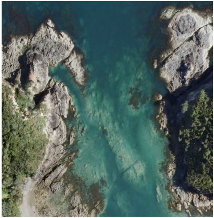
An entire generation of young divers snorkelling the shores of the idyllic anchorage of Oke Bay, including this channel between the mainland and Moturahurahu Island, probably think that its rocky seafloor bereft of kelp is natural. Such widespread annihilation of kelp forests, and loss of essential structural complexity in the reef, over several decades will have had unimaginable impacts on the overall ecology of the Bay of Islands through the loss of the host of animals and other algae associated with kelp forests. (Photo: Ocean Survey 20/201)
~~~~~~~~~~~~~~~~~~~~~~~~~~~~~~~
The widespread kina barrens in the Bay of Islands are almost certainly an example of, and result from, ecological overfishing. Some argue that pinning the explosion of kina on the overfishing of just a few predators is oversimplifying a very complex ecology—but they're yet to come up with defensible alternative explanations.
For the Bay of Islands, heralded around the world not only for its colourful history, but particularly for its stunning scenery and teeming marine life, the under-the-surface reality is a far cry from its pristine state.
Kelps are highly productive, fixing carbon, fuelling the ecosystem and providing habitat and food for all manner of animals and plants. Shallow forests are food and habitat for butterfish and other kelp-dependent fish. They also provide areas for spawning and larval settlement—and nursery habitat—where exposure to water movement and predation is reduced. All of these—and probably many other functions we aren't even aware of—have been lost.
No-take reserves typically lead to the return of fully functioning kelp ecosystems, the dependent life forms and ecological processes—the sea's mauri—restored. We've seen this in the no-take marine reserve at Leigh10 and elsewhere. Tools such as rahui, mataitai, taiapure—or elimination of just commercial fishing—simply don't cut the mustard because they can't be guaranteed to retain the very high levels of harvest control necessary, and remain in place long enough for fully functioning natural ecosystems to emerge. Top predators take decades to resume their roles, and even modest levels of fishing make recovery impossible.
Unless fishing pressure is dramatically reduced, there will be further loss of our shallow-water kelp. Is it fair and reasonable that we leave our mokos this awful legacy of barren reefs?
Acknowledgements
Thanks Vicky Froude and Chris Richmond for useful ways to improve my essay.
References
1. http://www.linz.govt.nz/hydro/projects-programmes/ocean-survey-2020
2. Cometti, R.; Morton, J. (1985). Margins of the sea. Exploring New Zealand's coastline. Hodder and Stoughton, Auckland.
3. Ayling, T.; Babcock, R. (2003). Goat Island. In The Living Reef. The ecology of New Zealand's rocky reefs. Craig Potton Publishing, Nelson. Pp 224-229.
4. Ling, S.D. plus 19 others (2014). Global regime shift dynamics of catastrophic sea urchin overgrazing. http://dx.doi.org/10.1098/rstb.2013.0269
5. Tegner, M.J.; Dayton, P.K. (2000). Ecosystem effects of fishing in kelp forest communities. ICES Journal of Marine Science 57: 579-589.
6. Ministry for Primary Industries (2013). Review of sustainability and other management controls for snapper 1 (SNA 1). MPI Discussion Paper 2013/31.
7. Francis, M. (2003). Snapper. In The Living Reef. The ecology of New Zealand's rocky reefs. Craig Potton Publishing, Nelson. Pp 186-191.
8. McKenzie, A. (2007). Preliminary stock assessment for trevally in the TRE1 fishery to 2004-05. Final Research Report for Ministry of Fisheries Research Projects TRE2004-01.
9. Starr, P.J.; Bentley, N.; Breen, P.A.; Kim, S.W. (2003). Assessment of red rock lobsters (Jasus edwardsii) in CRA 1 and CRA 2 in 2002. New Zealand Fisheries Assessment Report 2003/41.
10. Ballantine, B. (2014). Fifty years on: Lessons from marine reserves in New Zealand and principles for a worldwide network. Biological Conservation 176: 297-307.
Appendix. The primary resource for estimating the modern extent of kina barrens was the November 2009 Ocean Survey 20/20 aerial photographs of Land Information New Zealand.1 Each .tiff image is around 25 megs, and has a footprint approximately 0.5 km east-west and 0.75 km north-south. Adjacent images were joined, and kina-barren presence (red) and absence (green) interpolated over the broader area (with blue showing places where it was unclear one way or the other whether there had been kelp loss). The example given here is Rawhiti Peninsula.
